**WE ARE CLOSED, OFF-SITE, & NOT ACCEPTING RESERVATIONS while the company is undergoing restructuring & until further notice.**
Thank you for your understanding during this difficult time.
River trip! Let’s go!
– Canyon Country on:
- The Green River (Labyrinth & Stillwater Canyon)
- The San Juan River
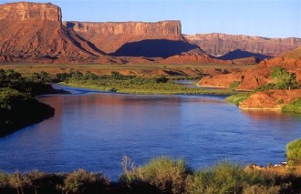
- The Colorado River
WE OFFER:
- SELF-GUIDED TRIPS:
GREEN RIVER – Multi-Day only Flat Water Canoe Trips (through Labyrinth & Stillwater Canyon)
**We DO NOT administer the Jet Boat pick-up at the Confluence for Stillwater, but rent the canoes and gear necessary for your trip and provide a shuttle service to the put-in only.**
COLORADO RIVER – Day & Overnight Flat Water Canoe Trips
- GUIDED MULTI-DAY (3+ Days) TOURS:
GREEN RIVER – Flat Water Canoe Trips (through Labyrinth Canyon)
SAN JUAN RIVER – Raft Trips
- LAND SHUTTLE SERVICE for the Green River (You have your own boat.)
- FRONT SHUTTLE for the Colorado River, “The Daily” (You have your own boat.)
- CAMPING EQUIPMENT RENTAL with Multi-Day Trip Booking
- DOG-FRIENDLY Day & Multi-Day CANOE Trips (Shuttled for a small fee.)
WE DO NOT:
- Rent RAFTS, KAYAKS, INFLATABLE KAYAKS, OR STAND UP PADDLE BOARDS.
- Have SINGLE DAY Guided Trips (MULTI-DAY Guided Trips only on the Green or San Juan River).
SHUTTLES ARE NOT PRIVATE! If you would like a private shuttle, you must pay for each seat in the 15 Passenger Van(s).
NOTE: IF YOU ARE LATE BY 15 MINUTES OR MORE, we may not be able to put you out on the trip that day!
***We SPECIALIZE in Multi-Day Excursions on the extraordinary Green River & the mystical San Juan River!***
~NO OTHER COMPANY does as many Self-Guided and Guided Trips through Labyrinth Canyon day in and day out as Moab Rafting and Canoe Company does and few companies in town service and specialize in this section of the Green River! In season, we are at Ruby Ranch and/or Mineral Bottom daily.~
Please BOOK EARLY to guarantee your reservation with us. Even with the largest canoe rental fleet in Moab, availability quickly becomes limited and books up faster each & every year for our specialized trips!
We welcome and outfit everyone from the Solo Boater to large School Groups, Scout Troops, Bachelor/Bachelorette Parties, and Reunions.
We’ve designed our website to provide you with a wealth of information and the tools necessary for you to put together your best trip. (THIS IS ONLY THE HOME PAGE! PLEASE NAVIGATE THE REST OF OUR SITE FOR DETAILED SPECIFICS ON EACH TRIP USING THE DROPDOWN MENU OR BY CLICKING ON THE DESIRED TRIP NAME.)
Discover your red rock river expedition of a lifetime with Moab Rafting and Canoe Company! You will come back for more, season after season, year after year! Labyrinth Canyon, in particular, starts off as a “Bucket List” trip, but undisputably turns into a yearly expedition, actualized by our long list of trusting repeat customers because of the Canyon’s beauty, peacefulness, and a draw beckoning us to escape the “noise” of the world and makes “Labyrinth Canyon, the best calm, flat-water float in the country!”
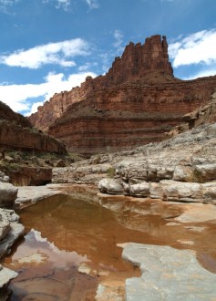
Labyrinth, by definition: a complicated irregular network of passages or paths in which it is difficult to find one’s way; a maze, an intricate and confusing arrangement.
The first river you paddle runs through the rest of your life. It bubbles up in pools and eddies to remind you who you are. — Lynn Noel
Great memories are made with our company! We hope to be able to get you out on the river!
Moab Rafting and Canoe Company prides itself in being a unique small business, that is a locally-owned and staffed shop run by canoe and raft enthusiasts! We consider ourselves ambassadors to Moab’s red rock canyon country, and we love to share the joy that we feel every time we hike these canyons or paddle these waters!
Take your Best Friend with you on your DAY or MULTI-DAY CANOEING adventure…Moab Rafting and Canoe Company is the only company in town that is a DOG-FRIENDLY, river trip company! WOOF!
Trust in our knowledge, expertise, and an unsurpassed passion for the rivers on which we journey. Our focus is on personalized customer service, flexibility, hard work, dedication, and hospitality, qualities that set us apart from the rest!
Our strongest points are our:
- Commitment to providing customized, commissioned, and tailored service for our clients who desire outdoor river adventure
- Professional quality equipment
- Our first-hand experience and knowledge of the rivers and the area
Years of experience in Utah, and on the Colorado Plateau, gives MRCC a depth of experience rarely seen. As owners, we are your direct line of contact and 100% hands-on and involved in EVERY aspect of the trips we provide (and know the name of every booked customer)! We can run a shop, plan your MRCC river trip, drive those rough and rugged backcountry dirt roads for your remote river trips, actively and frequently guide on those same rivers you are calling about, and read the river like no other!
- We are willing to work hard for you and give you the kind of experience you are hoping to have out on the river. As a result, the person who takes your reservation is not merely a receptionist booking your trip, but wears many hats and may also be your river guide and/or shuttle driver. We work everyday in season. Feel free to call or email us and if we don’t answer, PLEASE LEAVE A MESSAGE and we will get back to you once we return to the office. We are typically out running shuttles every single day to remote locations of the desert in the morning until late afternoon, on the other line working with someone regarding their trip details, actively out in the field and on the river Guiding one of our Multi-Day Trips, or in our boat yard with the pressure washer cleaning gear. We care about getting your trip arranged and can’t wait to get you out on the river for a memorable adventure! After all…life is better on the river!
- We want to provide our patrons with a place they can call a home away from home by establishing trust through our honesty and integrity, making friends, and building lasting relationships with every individual that walks through our door. Being a small business, we are non-commercial and have the ability to develop deeper, stronger, more personal bonds with our patrons. As such, we have a long list of repeat customers that seek us out year after year. We are not the fast food drive-thru provider in the river industry!
Our longer, multi-day trips are calling out to those expedition-minded folks who are interested in all that a river trip can offer, such as:
- Relaxing, unwinding, slowing down, escaping into the remote solitude of the backcountry wilderness, and taking in the fantastic beauty of the canyons and the river; and then,
- Being active, hiking, camping, dealing with unpredictable weather and the elements (wind, heat, cold), mud, sand, and whatever comes next! Expeditions are planned with one main objective in mind, but it is usually the “whatever” entering in that makes for the great stories and special memories.
A Self-Guided Trip is an expedition that is self-governing where one navigates and is self-sufficient and responsible for all of the paperwork, planning, footwork, and knowledge of equipment/gear, the area, the river, and route oneself. The Bureau of Land Management (BLM) can be a great place to start with providing suggestions, maps, instructions, directions, and items to see or do during self-guided tours.
A Guided Tour is an expedition where Moab Rafting and Canoe Company provides just about all you will need, including a crew that knows the river all too well, directs the route & times, information, places to hike and camp, and so much more! But, it still requires planning, experience, and equipment, all of which we offer.
One of our repeat customers commented, after doing a 10-day Guided, 84-mile river trip, “A trip like this is for everyone who wants to BE here. There are unavoidable discomforts involved in being on the river for so long, but the rewards more than make up for it.”
We are your Backcountry River Outfitter…
There are many variables to deal with in planning your expedition. A Self-Guided Green River Trip requires a high level of responsibility and your due diligence in extensive research, as you will be going into backcountry wilderness. This is not just a river that you can hop on without preparation! As navigator, you will have to pay attention to river mileage and your travel speeds. You are your own captain! The area is remote and services are non-existent. Your group must be self-contained and self-reliant to deal with emergency situations. Cell phone service is not available within the canyons. A satellite phone is optional, but highly recommended, although this too is not guaranteed to work within the canyons. Regarding Mother Nature and the river, as much as you want (and ask), we cannot give you absolutes, especially in terms of the extreme desert conditions and variances that occur in our environment day to day. This is why we speak in generalities and tell you to be well prepared for your trip! Weather is unpredictable and can change in an instant in the high desert and we have no control over it!
There are inherent risks and dangers to any river trip, even calm, flat-water, and those are magnified by taking a trip in the backcountry.
These are not “free flowing” rivers, so water use up river, as well as weather, causes spring trips to be very different from summer or autumn trips. Throughout many river seasons, we have found that it takes at least a few phone calls and/or emails to plan a great trip for great memories, and a few more to finalize it. Once again, we’ve designed our website to provide you with a wealth of information and the tools necessary for you to put together your best trip. Whether it is a solo or group trip, one day or several, communication is very important for ironing out details. But, it is up to you as a Self-Guided Tripper to prepare your group. Reference our extensive river equipment and camping rental gear for your convenience. We also have a FAQs Tab and a Packing List Tab for you to navigate. We will help with trip cost break downs, ideas and questions, and we’ll do our best to help you make your custom red rock river trip a reality!
“You can no more read the same book again than you can step into the same river.”
― Neil Gaiman
*The Green River is not a river that you can hop on without you preparing yourself. It is not Disneyland. If you are not willing to do the extensive research involved and IF YOU CANNOT HANDLE YOURSELF IN AN EMERGENCY SITUATION IN LESS THAN IDEAL CIRCUMSTANCES in our unique, extreme terrain and weather out on the river, YOU SHOULD NOT BE DOING A SELF-GUIDED TRIP and really need start with a GUIDED GREEN RIVER TRIP. As one of the few outfitters who put people out on this river everyday in season, we are finding more and more people going out unprepared, not heeding our advice and direction, cannot make decisions on their own, and needing the intervention of emergency services. So, in support of our extremely hardworking and busy Search and Rescue team in Moab, we are putting out this PSA. The most common issue we see every year: Kayakers/SUP-ers or others trying to filter the extremely silty river water instead of taking a vessel large enough or having a support vessel, such as a canoe, to carry the required minimum amount of fresh water to avoid dehydration in our extreme desert conditions.
Also, we are finding many people creating websites and blogs (who have done “A” trip or even several trips) with a lot of incorrect information/”advice” on Labyrinth Canyon. We are at the river daily, in season. The same rivers we are out on day-to-day, are not the same from day-to-day. It may have been accurate for their particular trip, under their particular circumstances. Please listen to the professionals who are out there daily…and there are only a couple of us outfitters that are! We would be remiss if we didn’t present the not-so-great with the all extraordinary when it comes to the Green.*
*NOTE for Shuttle Service: Avoid the excessive wear and tear on your vehicle in driving down our rugged backcountry roads, as well as paying for the gas, vehicle shuttle cost, as well as the cost of your precious vacation time all to have your vehicle moved! We can provide a convenient River Shuttle Service for those who have their own gear and do not need to rent gear from us. For more information, choose from the dropdown menu at the top of our website: Green River/River Shuttle Service drop. For local, in-town River Shuttle Service, choose: Colorado River/River Shuttle Service.
**MRCC’S Policy: BE NICE OR LEAVE…River trips are supposed to be fun, right?! We go out of our way to be exceedingly nice and, therefore, reserve the right to refuse service and trips (now AND in the future) to those who do not follow our policies and who are rude, disrespectful or abusive to our staff, company, and/or equipment.
CANCELLATION POLICY
We are sure that you have an excellent reason for cancelling, and we are very sorry to hear it, HOWEVER, below is our cancellation policy and you will be charged.
SELF-GUIDED MULTI-DAY Trips, Shuttles, Rental Equipment, ETC.: A $100 non-refundable per person deposit is required to secure your trip date for Self-Guided Multi-Day Trips. Due to the extensive planning of Multi-Day Trips for customers, it is not likely that we will be able to rebook your reserved dates if you cancel. Also, we more than likely have had to turn others away for your booked dates. The full amount of your trip (including rental equipment) is due and will be charged to your Visa or Mastercard only given 30 days from the date of your trip. CANCELLATIONS WITHIN 30 DAYS OF YOUR RESERVATION WILL NOT RECEIVE A REFUND. Regarding the possibility of having to cancel, we strongly suggest you purchase Trip Cancellation Insurance to protect your vacation investment, as there are NO EXCEPTIONS OUTSIDE THE CANCELLATION POLICY. It is our policy to reserve the right to cancel any trip at the last minute for any reason. Should this occur, no money will be exchanged. If conditions allow, we will postpone for a few hours or to the next day.
SELF-GUIDED SINGLE DAY Trips: The full amount of your trip is due and will be charged to your Visa or Mastercard only given at the time of booking. If you cancel within 14 days of your trip, you will receive a refund less $20 per person booked. CANCELLATIONS WITHIN 3 DAYS OF YOUR RESERVATION WILL NOT RECEIVE A REFUND. Regarding the possibility of having to cancel, we strongly suggest you purchase Trip Cancellation Insurance to protect your vacation investment, as there are NO EXCEPTIONS OUTSIDE THE CANCELLATION POLICY. It is our policy to reserve the right to cancel any trip at the last minute for any reason. Should this occur, no money will be exchanged. If conditions allow, we will postpone for a few hours or to the next day.
GUIDED Tours: A $250 non-refundable per person deposit is required to secure your trip date. Please contact us as early as possible if you need to make any changes. The full amount of your trip is due and will be charged to your Visa or Mastercard only given 60 days from the date of your trip. CANCELLATIONS WITHIN 60 DAYS OF YOUR RESERVATION WILL NOT RECEIVE A REFUND. Regarding the possibility of having to cancel, we strongly suggest you purchase Trip Cancellation Insurance to protect your vacation investment, as there are NO EXCEPTIONS OUTSIDE THE CANCELLATION POLICY. It is our policy to reserve the right to cancel any trip at the last minute for any reason. Should this occur, no money will be exchanged. If conditions allow, we will postpone for a few hours or to the next day.
FRONT SHUTTLE SERVICE for the Colorado River (“The Daily”): The full amount of your shuttle is due and will be charged to your Visa or Mastercard only given at booking 14 days from the date of your trip. CANCELLATIONS WITHIN 14 DAYS OF YOUR RESERVATION WILL NOT RECEIVE A REFUND. Regarding the possibility of having to cancel, we strongly suggest you purchase Trip Cancellation Insurance to protect your vacation investment, as there are NO EXCEPTIONS OUTSIDE THE CANCELLATION POLICY.
**We reserve the right to alter the river trip due to water flow, or lack thereof, or any other unforeseen circumstances. ALL MULTI-DAY TRIPS GO OUT in wind, rain, snow, sleet, shine or extreme heat! This is not Disneyland! We are in the high desert and our weather is extreme! There are inherent risks and dangers to any river trip, even calm, flat-water, and those are magnified by taking a trip in the backcountry. YOU NEED TO BE PREPARED for rainstorms, wind, blazing sun, intense heat and cold, etc. If this is looking like too much responsibility and YOU CANNOT HANDLE YOURSELF IN AN EMERGENCY SITUATION IN LESS THAN IDEAL CIRCUMSTANCES, YOU SHOULD NOT BE DOING A SELF-GUIDED TRIP and really need start with a GUIDED Green River Canoe Trip.**
We reserve the right at any time to change prices, products, policies, and services without prior notice.
We are a small company that books up throughout the season because of our service, expertise, and dedication in offering our specialized trips. ALL PRICES ARE FIXED, SO PLEASE, NO DISCOUNTS OR HAGGLING.
Our customers are welcome to park their vehicle in our lot for the duration of their trip.
NO CAMPING OR SLEEPING IN VEHICLES ON THE PROPERTY!
Leave no trace of your stay. You must pack out everything you pack in! Visit: lnt.org
“Take only memories, leave only footprints.”
Moab Rafting and Canoe Company is licensed in the State of Utah as a River Outfitter and Livery Company.